The iconic golden snail at Taman Mini Indonesia Indah
Taman Mini Indonesia Indah (TMII) or "Beautiful Indonesia Miniature Park" (literally translated) is a culture-basedrecreational area located in East Jakarta, Indonesia. It has an area of about 250 acres (1.0 km2). The park is a synopsis of Indonesian culture, with virtually all aspects of daily life in Indonesia's 26 (in 1975) provinces encapsulated in separate pavilions with the collections of Indonesian architecture, clothing, dances and traditions are all depicted impeccably. Apart from that, there is a lake with a miniature of the archipelago in the middle of it, cable cars, museums, Keong Emas Imax cinema, a theater called the Theatre of My Homeland (Theater Tanah Airku) and other recreational facilities which make TMII one of the most popular tourist destinations in the city.[1]
Since 2007 Taman Mini Indonesia Indah launched new logo with branding slogan Pesona Indonesia ("Indonesian Charm").
On December 31, 2014 World Peace Committee decided TMII as International Civilization Park and World Peace Theme Park.
History

Nitra, the mascot of TMII
The idea of presenting Indonesia in a small scale was conceived by former Indonesian
first lady,
Siti Hartinah, better known as Tien
Suharto. It came about at a convention on 8 Cendana Street at March 13, 1970. Through this recreational site, she hoped to cultivate national pride in more Indonesian people.
[1] A project called "Indonesian Miniature Project" was started by Harapan Kita Foundation in 1972. The concept of this culture-based recreational area was inspired by Indonesia's unparalleled natural riches and local folk diversity.
Characteristics
TMII was originally located on a public area of 145 ha, as farms and fields. Later, the team was able to convert these fields into a suitable location for the construction. The
topography of TMII is rather hilly, consistent with what the builders required. The team claimed the advantage of utilizing this uneven terrain was the ability to create interesting and diverse landscapes and enclosures, as well as reflecting the various characteristics of the Indonesian environment
Venues of Indonesian Provinces

The
Jaipongan dance performance in West Java pavilion in TMII.
Since each Indonesian province maintains its own unique and distinct cultures, shelters, attire and dialects, TMII built a model of each of the houses from Indonesian provinces. TMII attempted not only to reconstruct the homes of the various provinces, but also to create a realistic model of the environment and shelters of the various people of Indonesia.
[3] The venues, which are situated around the main lake in a similar fashion to the different islands of the
Indonesian archipelago, are thematically divided into six areas in respect to the main islands of Indonesia;
Java,
Sumatra,
Kalimantan (
Borneo),
Sulawesi, the
Lesser Sunda Islands,
Maluku and
Papua. Each pavilions featured in typical
vernacular Indonesian architecture of each provinces. Examples of Indonesian traditional vernacular houses are:
Joglo and Omah Kudus
Javanesehouses of
Central Java and
Yogyakarta pavilion;
Minang Rumah Gadang of
West Sumatra pavilion;
Malay houses of
Jambiand
Riau provinces;
Torajan Tongkonan and Bugis house of
South Sulawesi pavilion; and
Balinese house compound with intricately carved Candi Bentar split gate and Kori Agung gate.
It also displays various traditional costumes, wedding costumes, dance costumes, also ethnography artifacts such as weapons and daily tools, models of traditional architecture are in display to describes the way of life of its people. Each provinces pavilions also equipped with small stage, amphitheatre or auditorium for traditional dance performances, traditional music performances or traditional ceremonies that usually held in Sundays. Some of these pavilions also equipped with cafeterias featuring traditional
Indonesian cuisines and also souvenir shops offering various handicrafts, T-shirts and souvenirs.
Since 1975 until the 2000s, the original design of TMII consist of a model of the houses from the 27 provinces of Indonesia, including
East Timor. But after the secession of East Timor from Indonesia in 2002, the East Timor pavilion changed its status to become the Museum of East Timor. Also since Indonesia now consist of
33 provinces, currently the new province pavilions of
Bangka Belitung,
Banten,
West Sulawesi,
North Maluku,
Gorontalo,
Riau Islands, and
West Papua is being built in northeast part of the park.
Religious Buildings
The religious buildings of several official faiths is meant to showcase the inter-faiths tolerance and religious harmony of Indonesia. The religious buildings are:
Gardens and Parks
There are about ten gardens spread within TMII complex, but most are located primarily on the north and northeast side of the main lake:
- Orchid Garden
- Medicinal herbs Garden
- Cactus Garden
- Jasmine Garden
- Keong Emas (Golden Snail) Flower Garden
- Fresh Water Aquarium
- Bekisar (a type of rooster) Garden
- Bird Park
- Taman Ria Atmaja Park, stage and music performances
- Taman Budaya Tionghoa Indonesia, an Indonesian Chinese cultural park (under construction)
- Reptile Park in Komodo Zoological Museum compound. A fully grown Komodo dragon (Varanus komodoensis) nicknamed Bima resides in the reptile park near the eastern gate, which you can pet and take pictures with for Rp.5,000 ($0.60).
Technological Centre
Pusat peragaan Iptek or Science and Technology Display Centre is under coordination of Research and Technology Ministry. At the end of 2011 has 15 sites with about 300 science tools and visited by 341,000 visitor in a year. The sites are Robotic, Electric and Magnet, Mechanics, Mathematics, etc.
[5]
Museums

The
Tumpeng style Purna Bhakti Pertiwi Museum displaying artworks and souvenirs collections of
Suharto.

The Balinese style Indonesia Museum.
There are fourteen
museums at TMII:
Theatres
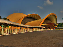
- Keong Emas (Golden Snail) Imax Theater
- Tanah Airku Theater
- 4D Theater
Monuments, Halls, Buildings and other Exhibits

Kala Makara main entrance

Sasono Utomo main building
- Kala Makara main gates
- Flower clock
- Tugu Api Pancasila, the main monument, an obelisk celebrating Pancasila
- Baluwerti, a twin gate with relief of Indonesian history on its wall
- Pendopo Agung Sasono Utomo (Grand Hall), the main building in Javanese Joglo style
- Sasono Utomo, exhibition hall
- Sasono Langen Budoyo, indoor stage and theater
- Sasono Manganti
- Sasana Kriya, multi purpose function hall
- Park Management Office
- Cokot Sculpture, a display of wooden sculptures by Cokot, a famous Balinese artist
- The Miniature of Borobudur
- APEC Memorial Monument and Garden
- Non Alignment Nations Friendship Monument and Garden
- The Miniature of Indonesian Archipelago on central lake
- Indonesian Archipelago Plaza and Stage
- Jati Taminah, a remnant of a large teak tree
- Kayu Gede (large wood), the display of large tree trunk
Rides
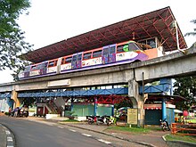
Wind powered
Aeromovel people mover ride around the park.
- Skylift Indonesia cable car
- Aeromovel Indonesia, a wind powered people mover
- Mini train around the park
- Boat ride on Indonesian archipelago lake
- Swan paddle boat on Indonesian archipelago lake
- Bicycle rent ride
- Car ride around the area
Recreation facilities

Istana Anak-anak Indonesia.
- Istana Anak-Anak Indonesia (The Castle of Indonesian Children)
- Taman Among Putro kiddy rides park
- Desa Seni dan Kerajinan handicraft center
- Rare books market
- Snowbay Waterpark swimmingpool
- Telaga Mina fishing pond
- Warna Alam outbound camp
Lodgings
- Desa Wisata hostel
- Graha Wisata Remaja youth hostel
Restaurants