Showing posts with label tour. Show all posts

Saturday, 11 March 2017

Kampung Naga, An Unique & Exotic Traditional Sundanese Village In West-Java Indonesia


Kampung Naga is a hamlet located in the area of Neglasari Village, Salawu District, Tasikmalaya Regency, West Java Province, Indonesia.
Kampung Naga is a village which is inhabited by a community in a very strong tradition of holding the remainder ancestors. The differences are visible when compared with other communities outside Kampung Naga. The community are living in the framework of an atmosphere in a traditional simplicity and environmental wisdom.
Kampung Naga is located not far from the main road that connects with the city of Garut Tasikmalaya. Villages are located in a fertile valley, with the boundaries, in the West Village by Naga forest. The forest is sacred because it is located in the ancestral cemetery. In the south is the rice fields, and in the north and east are surrounded by river Ciwulan, which the source of water comes from Mount Cikuray in Garut. The distance from the town of Tasikmalaya to Kampung Naga is approximately 30 kilometers, while the distance from the city of Garut is 26 kilometers. To reach Kampung Naga from Garut, Tasikmalaya, people must climb down the ladder in the wall (Sunda: sengked) to the bank of the river Ciwulan with the slope about 45 degrees with a distance of approximately 500 meters. Then through the paths into Kampung Naga. The settlement is easier to visit than the most ancient Sundanese village in Baduy.[1]


According to the data from Neglasari village, the surface soil of Kampung Naga hills with those used for land productivity can be fertile. Area of land in Kampung Naga is one of half a hectare, mostly used for housing, yards, ponds, and the rest is used for agriculture rice harvested twice a year.
The preservation of the village has been supported by national government beginning during the Suharto presidency, and it has been described as part of the "public face of regulation in Suharto's Indonesia".[2] The government provided concrete steps which connected the village to the outside world and battery powered radios as gifts for the village; tour guides were government-trained and reiterated the Naga people's desire for: self-sufficiency; the continuation of their traditions; and their desire to be model citizens.[3]


Source: Wikipedia

Friday, 9 September 2016

Exploring Indonesia in Several Hours, Come To Taman Mini Indonesia Indah!

Taman Mini Indonesia Indah

From Wikipedia, the free encyclopedia
Taman Mini Indonesia Indah Beautiful Indonesia Miniature Park
TMII Logo.svg
SloganKunjungi Taman Mini, Cintai Indonesia (Visit Taman Mini, Love Indonesia)
LocationJakarta TimurDKI Jakarta,Indonesia
Coordinates6°18′6″S 106°53′48″ECoordinates6°18′6″S 106°53′48″E
OwnerGovernment of Indonesia
Operated byYayasan Harapan Kita
General ManagerSugiono
Opened20 April 1975
Rides
Total5
Water rides2
Websitehttp://www.tamanmini.com
The iconic golden snail at Taman Mini Indonesia Indah
Taman Mini Indonesia Indah (TMII) or "Beautiful Indonesia Miniature Park" (literally translated) is a culture-basedrecreational area located in East JakartaIndonesia. It has an area of about 250 acres (1.0 km2). The park is a synopsis of Indonesian culture, with virtually all aspects of daily life in Indonesia's 26 (in 1975) provinces encapsulated in separate pavilions with the collections of Indonesian architecture, clothing, dances and traditions are all depicted impeccably. Apart from that, there is a lake with a miniature of the archipelago in the middle of it, cable cars, museums, Keong Emas Imax cinema, a theater called the Theatre of My Homeland (Theater Tanah Airku) and other recreational facilities which make TMII one of the most popular tourist destinations in the city.[1]
Since 2007 Taman Mini Indonesia Indah launched new logo with branding slogan Pesona Indonesia ("Indonesian Charm").
On December 31, 2014 World Peace Committee decided TMII as International Civilization Park and World Peace Theme Park.

History


Nitra, the mascot of TMII
The idea of presenting Indonesia in a small scale was conceived by former Indonesian first ladySiti Hartinah, better known as Tien Suharto. It came about at a convention on 8 Cendana Street at March 13, 1970. Through this recreational site, she hoped to cultivate national pride in more Indonesian people.[1] A project called "Indonesian Miniature Project" was started by Harapan Kita Foundation in 1972. The concept of this culture-based recreational area was inspired by Indonesia's unparalleled natural riches and local folk diversity.

Characteristics

TMII was originally located on a public area of 145 ha, as farms and fields. Later, the team was able to convert these fields into a suitable location for the construction. The topography of TMII is rather hilly, consistent with what the builders required. The team claimed the advantage of utilizing this uneven terrain was the ability to create interesting and diverse landscapes and enclosures, as well as reflecting the various characteristics of the Indonesian environment


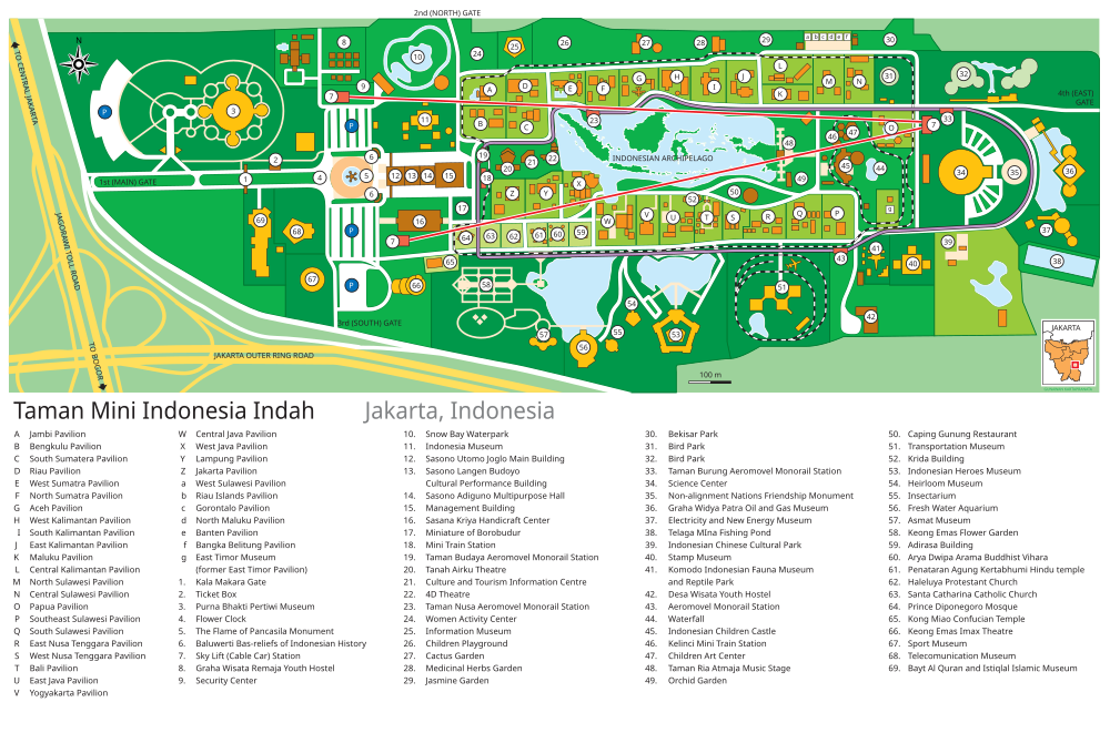
Taman Mini Indonesia Indah Map en.svg


Venues of Indonesian Provinces


The Jaipongan dance performance in West Java pavilion in TMII.
The miniature of Indonesian Archipelago in the center lake viewed from the cable car.
West Sumatra pavilion in TMII.
Since each Indonesian province maintains its own unique and distinct cultures, shelters, attire and dialects, TMII built a model of each of the houses from Indonesian provinces. TMII attempted not only to reconstruct the homes of the various provinces, but also to create a realistic model of the environment and shelters of the various people of Indonesia.[3] The venues, which are situated around the main lake in a similar fashion to the different islands of the Indonesian archipelago, are thematically divided into six areas in respect to the main islands of Indonesia; JavaSumatraKalimantan (Borneo),Sulawesi, the Lesser Sunda IslandsMaluku and Papua. Each pavilions featured in typical vernacular Indonesian architecture of each provinces. Examples of Indonesian traditional vernacular houses are: Joglo and Omah Kudus Javanesehouses of Central Java and Yogyakarta pavilion; Minang Rumah Gadang of West Sumatra pavilion; Malay houses of Jambiand Riau provinces; Torajan Tongkonan and Bugis house of South Sulawesi pavilion; and Balinese house compound with intricately carved Candi Bentar split gate and Kori Agung gate.
It also displays various traditional costumes, wedding costumes, dance costumes, also ethnography artifacts such as weapons and daily tools, models of traditional architecture are in display to describes the way of life of its people. Each provinces pavilions also equipped with small stage, amphitheatre or auditorium for traditional dance performances, traditional music performances or traditional ceremonies that usually held in Sundays. Some of these pavilions also equipped with cafeterias featuring traditional Indonesian cuisines and also souvenir shops offering various handicrafts, T-shirts and souvenirs.
Since 1975 until the 2000s, the original design of TMII consist of a model of the houses from the 27 provinces of Indonesia, including East Timor. But after the secession of East Timor from Indonesia in 2002, the East Timor pavilion changed its status to become the Museum of East Timor. Also since Indonesia now consist of 33 provinces, currently the new province pavilions of Bangka BelitungBantenWest SulawesiNorth MalukuGorontaloRiau Islands, and West Papua is being built in northeast part of the park.
After the recognition of Indonesian Chinese culture as the integral part of Indonesian culture in 2000, the new Indonesian Chinese pavilion and a Confucian temple was built within the park.

Religious Buildings

The religious buildings of several official faiths is meant to showcase the inter-faiths tolerance and religious harmony of Indonesia. The religious buildings are:

Gardens and Parks

Spherical cage Bird Park.
There are about ten gardens spread within TMII complex, but most are located primarily on the north and northeast side of the main lake:
  • Orchid Garden
  • Medicinal herbs Garden
  • Cactus Garden
  • Jasmine Garden
  • Keong Emas (Golden Snail) Flower Garden
  • Fresh Water Aquarium
  • Bekisar (a type of rooster) Garden
  • Bird Park
  • Taman Ria Atmaja Park, stage and music performances
  • Taman Budaya Tionghoa Indonesia, an Indonesian Chinese cultural park (under construction)
  • Reptile Park in Komodo Zoological Museum compound. A fully grown Komodo dragon (Varanus komodoensis) nicknamed Bima resides in the reptile park near the eastern gate, which you can pet and take pictures with for Rp.5,000 ($0.60).

Technological Centre

Pusat peragaan Iptek or Science and Technology Display Centre is under coordination of Research and Technology Ministry. At the end of 2011 has 15 sites with about 300 science tools and visited by 341,000 visitor in a year. The sites are Robotic, Electric and Magnet, Mechanics, Mathematics, etc.[5]

Museums

The Tumpeng style Purna Bhakti Pertiwi Museum displaying artworks and souvenirs collections of Suharto.
The Balinese style Indonesia Museum.
There are fourteen museums at TMII:

Theatres

  • Keong Emas (Golden Snail) Imax Theater
  • Tanah Airku Theater
  • 4D Theater

Monuments, Halls, Buildings and other Exhibits

Kala Makara main entrance
Sasono Utomo main building
  • Kala Makara main gates
  • Flower clock
  • Tugu Api Pancasila, the main monument, an obelisk celebrating Pancasila
  • Baluwerti, a twin gate with relief of Indonesian history on its wall
  • Pendopo Agung Sasono Utomo (Grand Hall), the main building in Javanese Joglo style
  • Sasono Utomo, exhibition hall
  • Sasono Langen Budoyo, indoor stage and theater
  • Sasono Manganti
  • Sasana Kriya, multi purpose function hall
  • Park Management Office
  • Cokot Sculpture, a display of wooden sculptures by Cokot, a famous Balinese artist
  • The Miniature of Borobudur
  • APEC Memorial Monument and Garden
  • Non Alignment Nations Friendship Monument and Garden
  • The Miniature of Indonesian Archipelago on central lake
  • Indonesian Archipelago Plaza and Stage
  • Jati Taminah, a remnant of a large teak tree
  • Kayu Gede (large wood), the display of large tree trunk

Rides

Wind powered Aeromovel people mover ride around the park.
  • Skylift Indonesia cable car
  • Aeromovel Indonesia, a wind powered people mover
  • Mini train around the park
  • Boat ride on Indonesian archipelago lake
  • Swan paddle boat on Indonesian archipelago lake
  • Bicycle rent ride
  • Car ride around the area

Recreation facilities

Istana Anak-anak Indonesia.
  • Istana Anak-Anak Indonesia (The Castle of Indonesian Children)
  • Taman Among Putro kiddy rides park
  • Desa Seni dan Kerajinan handicraft center
  • Rare books market
  • Snowbay Waterpark swimmingpool
  • Telaga Mina fishing pond
  • Warna Alam outbound camp

Lodgings

  • Desa Wisata hostel
  • Graha Wisata Remaja youth hostel

Restaurants


Monday, 5 September 2016

Kawah Putih, A Beautiful White Crater in Bandung Southern

Kawah Putih

From Wikipedia, the free encyclopedia

Kawah Putih
Kawah Putih (English: White Crater) is a striking crater lake and tourist spot in a volcanic crater about 50 km south of Bandung in West Java in Indonesia.[1]
Kawah Putih lake (7.10° S 107.24° E) is one of the two craters which make up Mount Patuha, an andesiticstratovolcano (a "composite" volcano).[2] Mt Patuha is one of numerous volcanoes in Java. Kawah Putih crater lake itself represents a relatively stable volcanic system with no records of significant activity since around 1600.[3]
The Kawah Putih site was opened to visitors in 1987. The lake is 2,430 meters above sea level so the local climate is often quite chilly (temperatures are frequently around 10 degrees Celsius). This makes a brisk change from the humidity of the north Java plain and the capital city of Jakarta. Kawah Putih is a sizeable highly acid lake (pH 0.5-1.3) which changes colour from bluish to whitish green, or brown, depending on the concentration of sulfur and the temperature or the oxidation state.[4] The sand and rocks surrounding the lake have been also leached into whitish colours through interaction with the acidic lake waters (with possible mineral precipitation as well).


History

The lake is said to have been first documented in the western world in 1837 by Dr Franz Wilhelm Junghuhn, a German botanist who carried out a considerable amount of research in Indonesia until his death in Lembang, just north of Bandung, in 1864. At the time, there were various local stories about the history of the area. Birds were said to be reluctant to fly near the region and villagers in the area tended to regard the forest around the lake as eerie and somewhat mysterious. These stories prompted Dr Junghuhn to investigate. He discovered Kawah Putih. There was formerly a sulfur mine at the crater although production has now ceased. A sulfur plant known as the Zwavel Ontgining Kawah Putih was first established near the lake during the period of Dutch rule in Java. The plant was later taken over during World War II by the Japanese military and operated under the name Kawah Putih Kenzanka Yokoya Ciwidey.[5] Entry points to various tunnels which represent the remnants of these mining activities can be seen at several points around the current site.
Over a century after Franz Wilhelm Junghuhn first discovered the lake, in 1991 the Indonesian state-owned forestry firm Perhutani Unit III Jawa Barat dan Banten(Forestry Unit No III for West Java and Banten) began to develop the site as a tourist spot


The site


View of Kawah Putih from the crater floor
The surrounding area is heavily forested. There is a pathway down to the lake which is surrounded by the high walls of the crater nestling into the side of Mt Patuha. The smell of sulfur is strong because there is a good deal of steam and sulfurous gas bubbling from the lake. There are tracks around the lake and through the nearby forest including to the peak of Mt Patuha. Visitors can walk around the crater area or sit in the various shelters. Local plants not widely found in lower altitudes in Java includejavanese Edelweiss and Cantigy (Vaccinium varingifolium). Animals and birds which may be spotted include eagles, owls, monkeys, mouse deer, and forest pigs. Panthers, leopards and pythons have also sometimes been seen in the nearby forest.
A range of simple facilities exists near the lake. There is ample parking and public toilets. Entrepreneurial vendors sell trinkets and food. The site is well-signposted. Local farmers often take the opportunity to sell strawberries (widely grown in the area), steamed corn, and various other items such as pumpkin seeds (pepita).
Kawah Putih and the surrounding area (where there are resort facilities such as hot spas) is a popular spot for people from Bandung. On weekends and on holidays, quite large numbers of Indonesian tourists visit Kawah Putih. The site is so far less well-known to international tourists. According to Perhutani staff at the site, up to 10,000 people might visit on busy holidays and the total number of visitors is perhaps 300,000 per year.


Access[edit]

Access is gained from the left of the main road travelling south by entering the park and proceeding along a 5 km access road.[7] Travel time from the centre of Bandung, depending on traffic in and around Bandung, is perhaps two hours. The turnoff from the main road to Kawah Putih is hard to miss: there is a large signboard to the left of the main road and a prominent entry gate. The entry facilities and the crater location are well-managed by staff from the state-owned forestry firm Perhutani.
The usual arrangement is for visitors to leave their vehicles in a main carpark at the entry to the site and catch one of the regular mini shuttlebuses (leaving every five minutes or so) for the 5 km to the crater. For Indonesian citizens, the cost of entry to the site (October 2011) is Rp 15,000 plus Rp 5,000 for the return minibus ride (total of Rp 20,000, around $US 2.20). Charges for foreign visitors are slightly higher. Visitors who prefer to drive in their own vehicles up to the crater must pay a significantly higher charge (Rp 150,000, or $US 17 per vehicle plus tickets for passengers).[8] Tickets are issued by Perhutani staff and include insurance while at the location.[9]
The main road is the busy road south from Bandung through the town of Soreang, the capital of the Bandung District, continuing down through the crowded Pasir Jambu township. Minibuses ply the route southwards from Bandung and, depending on traffic, can take up to two hours to reach the entrance to the Kawah Putih area.[10] There are many thousands of small market-crop farmers in the fertile valley to the south of Bandung which leads up towards the Kawah Putih area. Local food-crops grown include a wide range of fruits and vegetables. A strawberry industry is well-established in the area and many strawberry farms have fruit for sale along the side of the highway.[11]
Accommodation is available at various hotels in the Patuha area close to the nearby town of Ciwidey and also in Soreang